|
 |
BostonMassachussetts, USA (America)
|
Disclaimer: Maps are copyrighted. The previews on this page are for informational purposes only. Please respect copyright and always refer to original maps.
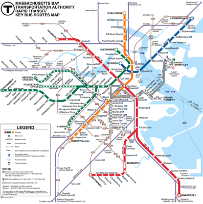
2017 – Green Line extension via Lechmere and Union Square to Washington St. 3 stations.
2019 – Green Line extension to Gilman Square, Lowell Street, Ball Square, and College Avenue 3 stations.
Examples of interesting station design:
 |
BostonThough the overall appearance of America's first subway is not that great, they started to include works of art in stations in 1967 and continue to do so with new stations. Murals, sculptures and other types of artworks have been acquired through donations and art competitions [mbta.com].
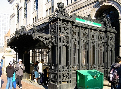
Photo [Madhava Enros, madhava.com]: Ornate wrought-iron entrance structure built in 1917 at Copley station.
 More Boston photos... More Boston photos...
|
Try the following tour, recommended by residents or metro enthusiasts:
On the Red Line you get a good view over the Charles River on the Longfellow Bridge between Charles/MGH and Kendall.
Seashore Trolley Museum, Kennebunkport, Maine. 75 miles north of Boston, this is the world's oldest and largest museum of mass transit vehicles. Among different types of tram vehicles and buses, it hosts a range of historical subway cars from Budapest, Boston, New York, Chicago, Philadelphia, Cleveland, and Staten Island. Since 1939.
Address: 195 Log Cabin Road, Kennebunkport, Maine, tel. (207) 967-2800. At Saco (Amtrak station, 8 miles from the museum) metro station.
Hours (check before visiting): 10am-5pm every day from first Saturday in May to last Sunday in October. Admission: $10. Features: Train rides, education programs, museum store.
Reference: trolleymuseum.org (official website).
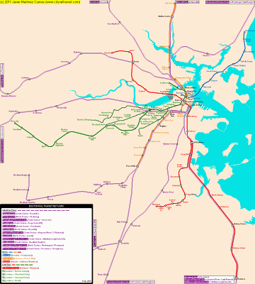
Boston once had an elevated line above city streets - elevated in the suburbs, with two alternative routes (one elevated, one underground) across the central area. This has gradually evolved into the present Orange Line of the subway. The central elevated route closed in 1938 without replacement, while the northern section was replaced by the current section of Orange Line (alongside a main line railroad) in 1975. The southern section was "replaced" in 1987 by a section of Orange Line subway on a somewhat different alignment - so different, in fact, that more recently part of the Silver Line (a conventional bus route, but marketed as if it were a subway line) has been introduced on the streets that the Orange Line once ran above. So, the only original section of line left is the underground section (and even that isn't quite original - elevated trains had to run through streetcar tunnels initially, while this section was finished). The last short section of elevated alignment in the city - actually part of the light rail Green Line - went in 2004. Boston has recently also got rid of an elevated freeway through the city centre, replacing it with road tunnels ("The Big Dig"). A streetcar or tram tunnel has been partly or wholly abandoned.
US Boeing LRT family
Members: Boston, San Francisco (MUNI),
Characteristics: Same trains.
Atlantic Ocean: Revere Beach and Wonderland stations on the Blue Line. Andrew station (underground) with a short walk to Carson Beach. Savin Hill station for Savin Hill and Malibu beaches. North Quincy station for Quincy's Tenean Beach and Wollaston station for Wollaston Beach. Orient Heights station.
Atlantic Ocean: In Boston's MBTA commuter rail, the stations in Rockport, Manchester and Beverly Farms (all on the Rockport Line) are a short walk from beaches on the Atlantic Ocean.
 | On the Red Line you get a good view over the Charles River on the Longfellow Bridge between Charles/MGH and Kendall.
Photo by metrobits.org |
On older trains, the doors make a "ding ding" or "ding dong" sound. There are new trains with automated announcements on the Red and Green Lines: As a train leaves a station, it says "Next stop, [name]". As the train enters a station, it says "Entering [name]". There is no announcement for closing doors, just "Beep beep". At major transfer points where rail lines cross, after the "Entering" announcement, the train says "Change here for the [name] Line" (such as the Green Line or Red Line, etc.)
Videos of other metros
Generic Links for Boston The T
Line history at cityrailtransit.com
Wikipedia entry at wikipedia.org
Urbanrail.net entry at urbanrail.net
Railway Gazette search at railwaygazette.com
Discussion at skyscrapercity.com
Transit map at Google Maps
Transit map at öpnvkarte.de
System maps at Google Images
System photos at Google Images
City information at wikipedia.org

This page: http://mic-ro.com/metro/metrocity.html?city=Boston
© 2004-2016 metrobits.org
Home —
City Pages —
World Metro Database —
Metro Arts & Architecture —
Metro Logos —
Resources —
Forum —
About
|


 Printer-friendly